
Ship-Handling at Burns Harbor – Winter 1984

~
The Great Lakes… 84% of the continent’s fresh water… a different story in every drop.
By Alan F. Gintz: As told to R. E. Kennington, Lt. Col., U.S. Army, Ret.
Burns Harbor, which lies in the Indiana sand dunes at the extreme southern end of Lake Michigan, was opened to lake traffic in September, 1969. I was informed by men who sailed there in the early days of the port that it was not yet shown on the navigation charts, and, since the Bethlehem fleet had not traded regularly in southern Lake Michigan, the captains and mates were not familiar with the shoreline. They depended initially on photographs of the shore and structures thereon to determine their bearings. The area is subject to frequent fog and haze, which is sometimes a problem when making a landfall. In such a case, the harbor entrance lights are not sufficiently prominent to be of great assistance until within a couple miles of the entrance.
One of the mates told me of an experience he had in approaching the harbor on a hazy day shortly after it was opened. As their boat neared the beach, the steel mill and shoreline appeared out of the haze, but both he and the captain were of the opinion that something was amiss. After studying the landmarks nine miles to the east through binoculars, they realized that the objects seen were not structures at Michigan City, as they had supposed, but were, in fact, the buildings and furnaces at Burns Harbor, so they were headed directly into Gary. Since that time, all personnel have become familiar with the terrain and landmarks, to include their images on radar.
We generally steer the approved Lake Carriers courses. From a departure point 20 miles plus or minus east-southeast of Rawley Point, we steer for a point one mile east of the harbor entrance. This course, between 177 and 180 degrees, is over a distance of 169 miles down the middle of the south half of Lake Michigan. We are out of sight of land until the Chicago skyline appears to the west. Then the steel mills along the south shore come into view. What we then look for is a tall smokestack of the Northern Indiana Public Service Company’s power plant on the beach about one mile east of the harbor entrance. It can be seen, in clear weather, for 18 or 20 miles. By heading on it, we will end up sufficiently to the east to be able to make a slow right turn into the harbor.
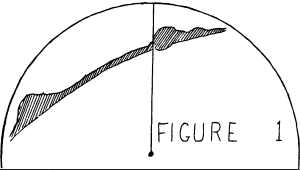
Image provided in the Inland Seas 1984 Winter issue.
In reduced visibility, when we are using the radar to make our approach, echoes of prominent structures begin to appear on the screen at 16 to 20 miles, followed shortly after by the outline of the shore. Before the radar picks up the detail of the breakwall, we can recognize bulges of ground clutter caused by structures at Michigan City to the east, burns Harbor ahead and Gary to the west. By identifying the bulge which represents Burns Harbor, we can steer on the left edge of it, and we are heading approximately on the power plant (Figure 1).
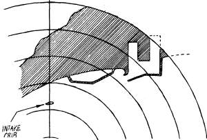
Image provided in the Inland Seas 1984 Winter issue.
From about ten miles out, the radar will begin to show detail of the break- walls and harbor. There is a water intake crib out in the lake, just off the power plant, which the radar will detect at close range. We can steer on that, knowing it is the equivalent of steering on the smokestack in good visibility (Figure 2) .
A northwest through north-northeast gale or storm can cause us to go to anchor out in the lake in order to wait for the wind to change direction and for the seas to abate. It can be a most uncomfortable place to sit at anchor, as there is no protection.
Before the Bethlehem boats were fitted with bow thrusters, taking a vessel not so equipped into the harbor without a tug usually called for dragging the stern anchor. This permitted the captain to ring up occasional high ahead speeds to provide instant rudder responses, while, at the same time, keeping the boat’s headway at the desired minimum. He would start to check down from full lake speed about four or five miles out and proceed at half speed or less, coming down to slow speed while going through the entrance (Figure 3).
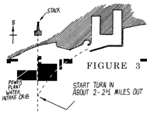
Image provided in the Inland Seas 1984 Winter issue.
About one and a half miles out, he would call for the stern anchor to be dropped, with a “shot”1 to a “shot and a half’ of chain in the water.’ This was a short enough length of chain to prevent stoppage of the boat provided some ahead engine was applied, dragging the anchor over the sand or mud bottom. Once the stern anchor was dropped, the captain would work the boat to the right, giving the wheelsman various landmarks (buildings, stacks, towers, etc.) to steer on by day, and shore lights by night, or, in reduced visibility, compass courses. These were never the same, depending on the wind and seas, and the set of the boat.
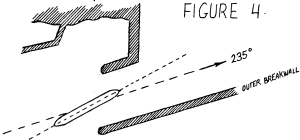
Image provided in the Inland Seas 1984 Winter issue.
While making its entry, the boat was usually headed somewhat to the left of the axis of the entrance channel. This was in anticipation of a sharp left turn to be made to avoid striking the Port of Indiana dock (Figures 4 and 5). With the boat at very slow speed, still dragging the stern anchor, the stern was brought to within 75 to 100 feet of the north breakwall. The distance from the wall was monitored by the mate tending the stern anchor, who called off the distances from the wall over the PA phone or the walkie-talkie. Edging his boat to the left, the captain ordered half or full ahead and hard left rudder, beginning the swing which had to be made fast enough to clear the Port of Indiana dock, while still not so fast that he would be unable to steady the boat somewhat to the left of the inside comer of the Bethlehem dock, which is located in the east arm of the harbor. Meanwhile, he had to avoid running his stern up on the north breakwall.
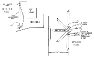
Image provided in the Inland Seas 1984 Winter issue.
Once steadied up and heading in toward the dock, he would usually face a problem caused by the ever-present barges moored close to the unloading dock. He would prefer to put his bow onto the dock as quickly as possible and slide it along the dock, in order to get the headway off the boat before reaching his tie- up spot, near the south end of the harbor arm. The presence of the barges required him to stay out in the channel to avoid them while stopping short of the end of the dock.
When the bow touched the dock, he would land the deck hands, get the for- ward wires out, keep the bow checked up to the dock and, as soon as the stern was clear of the barges, swing it in, put out the after wires and then use the wires and astern engine to bring the boat to a stop. Once the boat was tied up, the stern anchor was heaved up and the wires were used to shift the boat ahead or astern, as necessary, to spot it in position for the unloading cranes.
After bow thrusters were installed on the smaller boats in the fleet, Johnstown, Sparrows Point and Arthur B. Homer, the use of the stern anchor was discontinued except in unusual circumstances of weather.
Bringing the fleet’s big 1,000 footers, Stewart J. Cort, Burns Harbor and Lewis Wilson Foy into port is an altogether different story. Outfitted with bow and stern thrusters, twin screws and twin rudders, they are extremely maneuverable, while at the same time they require the exercise of the same degree of alertness and caution necessary in handling any vessel subject to the natural and mechanical dangers always present while afloat. In spite of their size, which fills the outer basin, the 1,000 footers can be stopped short of the Port of Indiana dock. With both rudders put hard left, the starboard propeller put ahead, the port propeller astern, the bow thruster pushing left and the stern thruster pushing right, they can be turned on a dime.
Once pointed toward the inner comer of the dock, the barges are a lesser problem than for a single screw, single rudder vessel. The captain can stay 100 to 200 feet off the barges, angle in toward the berth, stop, then use both thrusters pushing to port in order to push the boat right into the dock. Similarly, with the big boats, backing away from the dock, swinging the stern to the west in the outer basin, and heading out into the lake is relatively simple.
Getting the smaller boats out, especially before they were equipped with bow thrusters, was more difficult. Often a tug was taken on the bow. After letting go the wires, the stern was kicked away from the dock with ahead engine and left rudder. As the tug drove the boat astern against the bow tow line, the rudder was eased and the engine stopped or used only occasionally on slow astern. Until the stern reached the end of the Port of Indiana, the boat was about in the middle of the east arm. At that time, ahead engine and left rudder were applied and the tug pushed the boat astern into the outer basin. Then the bow was pushed to the north, toward the entrance channel. At the proper time, the captain signaled to have the tow line taken in, steadied the boat in the entrance gap, and headed out into Lake Michigan.
When a tug was not available or the captain did not want to wait for one, he would wind the boat on the dock, and leave without assistance. This involved shifting the boat north along the dock using the boat’s wires until the bow came even with a timber turning pad on the dock. Then the number one and number two wires and the forward breast wire were led out to port. When the wires were out, half ahead engine and left rudder were applied and the stem came into the turning pad. As the stern swung out from the dock, the stem was held from slipping along the dock by the wires which were being paid out by the automatic tension winches. When the boat was almost perpendicular to the dock, the three wires were let go to port and put out to starboard, the power from the ahead engine holding the stem into the timbers while this was done. When the wires were put out to starboard, the boat continued to swing around, the wires again preventing the stem from slipping along the dock.
After the turning movement was completed and the boat was positioned starboard side to the dock, the forward wires were let go, the number three and four wires were led aft and hung onto as the engine was put ahead, left rudder applied, and the bow veered out from the dock. With the bow angled out sufficiently, the wires were let go, the stern was kicked out with right rudder, and the vessel proceeded out the east arm, making a right turn to the lake.
There was frequently a salty tied up at the Port of Indiana opposite the Bethlehem dock. In that case, the winding maneuver afore-mentioned would be limited to a boat of not over 700 feet in length, since the width of the east arm is 820 feet. The breadth of a salty does not exceed 75 feet, because of the limitations imposed by the Seaway locks, so, in such case, there would be a clearance of only 45 feet between the laker and the salty when the former was perpendicular to its dock.
1 A “shot” of chain is 15 fathoms (90 feet) in length. Lake boats usually carry six shots of chain for each anchor (sometimes five for the stern anchor). The connecting link between shots is painted red and marked with turns of baling wire to assist in identifying the link if the paint becomes faded. Several links on each side of the connecting link are painted white, so that when the chain runs out rapidly the mate can count the shots and know when to order the brake applied to the windlass.
Read More of Inland Seas Online
About the Author: Alan F. Gintz, a native of New Philadelphia, Ohio, pursued a youthful interest in ships by training for a sea-faring career at the United States Merchant Marine Academy, Kings Point, New York, graduating in 1975.
Cadet time spent on Great Lakes vessels led him to seek a career on the Lakes, where, since 1976, he has been employed as third, second and first mate on ships of the Bethlehem Steel Corporation’s Great Lakes Steamship Division. Now a resident of Marietta, Ohio, his non-sailing time is occupied with historical interest in Ohio and western rivers steamboats.
Robert E. Kennington, Lt. Col., US Army (Retired), is a native of Michigan City, Indiana, but after a twenty-five year army career is now a resident of Sonoma, California. (For more detail on Col. Kennington’s military career, see page 94, Inland Seas® Summer 1979). This article is the result of several years’ correspondence between the authors, and an interview aboard ship at burns Harbor, Indiana, and reflects Col. Kennington’s continuing interest in Great Lakes’ history.

