
The Iron Age Dawns on Lake Superior — Winter 1997

~
The Great Lakes… 84% of the continent’s fresh water… a different story in every drop.
Author: Nancy A. Schneider
Many things have been around so long we cannot remember when or where they were first noticed. For example, we know copper was used in prehistoric times and in ancient Egypt; earliest specimens date back to 4500 B.C. Even in the United States, settlers discovered ageless arrowheads fashioned from the metal.
But the discovery of Lake Superior iron ore came late in this country’s schematic and we can pinpoint its exact moment of discovery.
William A. Burt, United States deputy surveyor and his party, (Jacob Houghton, barometerman, younger brother of Douglas Houghton; H. Mellen; R.S. Mellen; James King and two Native Americans, John Taylor and Michael Doner) were engaged in surveying the Upper Peninsula of Michigan using Burt’s new solar compass. The accuracy of the surveys made with this new compass was astounding. Still it was a new device, so the compassman simultaneously ran lines using the older magnetic compass.
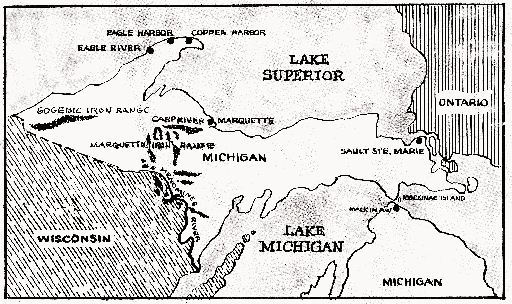
On September 19, 1844, the survey party was running a section line between future Negaunee and Ishpeming (east boundary of township 47 north, range 27 west), when the magnetic compass gave a remarkable reading. The compassman could hardly believe his eyes and called the crew to view his compass. The men were astonished — the north end of the needle was actually moving southwest — a variation of 87 degrees!
No one was more excited than Burt who said, “Boys, look around and see what you can find.”
William A. Burt
Born in Worcester County, Massachusetts, on June 13, 1792, William A. Burt’s parents, Alvin and Wealthy Austin Burt, moved him almost immediately to Montgomery County, New York. Burt farmed with his father days, and studied at home evenings. By age 14 he knew quite a lot about astronomy and had mastered the art of surveying. At 17, he moved with his family to Erie, New York. He saw service in the War of 1812.
In 1817, Burt worked his way west to St. Louis doing odd jobs and surveying, and in 1822 – built a saw mill at Auburn, Oakland County, Michigan while trying to get work as a government surveyor. Failing this, he bought a tract in Washington, Macomb County, where he built another mill and succeeded in securing a government position as county surveyor for the Michigan Territorial County where he promoted the St. Marys Falls Ship Canal.
In 1833 the United States surveyor general appointed William Burt United States deputy surveyor for the district northwest of the Ohio. In this work, Burt was confronted with a major problem — variations of the magnetic needle compass resulted in survey inaccuracy. Surveyors had been working around the problem for years, but Burt could not settle for surveys that only gave the illusion of truth.
He began to work on a solution. Burt thought that if the local disturbances which led to the variations could be overcome, surveyors could be more accurate.
Burt discarded the magnet and built a sun or solar compass. The solar compass is built like a clock with an hour hand and a pin which stands straight up on the clock’s face. The user moves the compass dial until the pin casts a shadow over the hour hand. In that position, the twelve o’clock mark points north. There were problems . . . the time noted by the pin’s shadow was local apparent time (the same time indicated by a sundial) which can differ by as much as 16 minutes from the time shown by a clock. To find the difference, a table listing the difference for each day of the year must be consulted. Also, the structure of the solar compass has to be varied depending on the latitude at which it is used. And, of course it works only in bright daylight. But the solar compass was a major improvement over its predecessor.
In 1835, Burt exhibited a model of his solar compass at the Franklin Institute in Philadelphia and was granted a Scott’s Legacy Medal. Four years later, he brought the finished solar compass to the same institute; they awarded him their highest commendation. In 1847, he wrote a user’s manual for the solar compass. Prince Albert awarded him a prize for his invention at the 1851 World’s Fair. It was said of Burt’s compass, “It seized a sunbeam as it fell and compelled it to point out the magnetism and poles of the earth, and thus determine the latitude, true meridian, azimuth, variation of the magnetic needle and local time, a mode of surveying independent of the magnetic needle.”
Back To The Survey 1844
Under Burt’s direction, each member of the survey party set out in a different direction. They soon discovered this was wasted effort because anywhere they cleared away dirt or moved the sod, iron ore made its appearance.
Burt was amazed, “How could they survey this country without my compass?” How, indeed.
History records the diligence of the survey crew, the accuracy of their reports and the fact that none of the surveyors made any effort to profit from their discovery.
William Ives, the compassman, was particularly noted for his care and diligence, and for his courageous spirit. One story details how Ives was severely wounded in one foot while working at the mouth of the Carp river. The survey party reluctantly abandoned him to continue their mission. The next day, to the surprise of everyone on the crew, Ives appeared at their camp in Negaunee having traveled the entire distance — over 140 miles — on improvised crutches. Considering the rugged terrain, totally impossible; but this story dramatizes the respect he commanded from his peers.
The surveyors recorded their findings, but shared the information with very few people — among the few, Louis Nolan, a First Nations man living at Sault Ste. Marie and an old Chippewa chief named Madjigijig, who camped at the mouth of the Carp River and considered the entire area his hunting ground.
Enter Everett of Jackson
In the spring of 1845, Philo M. Everett of Jackson, Michigan, responded to reports of copper and silver in the Lake Superior region.
On June 16, 1845, the Secretary of War issued seven permits to Everett’s party to pre-empt mineral locations. Congress legalized the act and said anyone could locate a mile square on the south shore of Lake Superior by leaving a person in charge of the location.
On June 20, Everett and four others set out for Copper Harbor. Arriving at Sault Ste. Marie, they met Louis Nolan who piqued Everett’s interest with stories of surveyors and ore deposits.
Everett, dreaming of copper and gold, asked what kind of ore. Nolan was only sure the ore was not gold. When samples were presented for his comparison, he also eliminated the copper and instead fingered a piece of Galena lead ore as being similar.
Everett was puzzled as to what ore Nolan had seen and since he had never heard of iron in this district, it never occurred to him Nolan meant iron ore. But Nolan’s reputation for truth and reliability made Everett want to examine Nolan’s ore firsthand.
Nolan offered to show Everett the way, claiming he had coasted the length of the lake many times on both sides, traveling many times to Hudson’s Bay as a clerk for that fur company. Everett wrote of his decision in Volume II of the Michigan Pioneer Collections:
A fur company clerk is quite a different thing. He must be able to write a fair hand, be a good accountant, and be able to take a ninety pound pack on his back and travel all day from one Native American camp to another, collecting furs and living entirely on wild meat, mostly rabbits, for the fur companies only supplied bread food enough to last their clerks to headquarters. The ninety pound pack consists of Native American goods, and that is the standard weight of all fur companies’ packs. Knowing these facts before, I was at once satisfied [Nolan] was the man for us.
Two days later, with his pack of blankets, tent cloth and ancient shot gun, Louis Nolan reported for duty at Everett’s tent.
We were not long in finding out that we had made a wise choice in our coaster. [Nolan] knew every point and every stream that entered the lake. When it came time to camp, he would run the boat ashore at the mouth of a stream where we could catch all the speckled trout we wanted. He never left his seat on the stern of the boat. When we sailed, he steered; when we rowed he paddled and steered.
Landing at the site that would soon be Marquette, the party traveled 15 miles through dense forest to Teal Lake where they met Madjigijig who led them to deposits.
We found the ore just as [Nolan] had described it. A perpendicular bluff fifty feet in height, of pure solid ore, looking like rock, but not rock. Climbing a steep elevation, at the top, to a precipice many feet deep. Hundreds of tons of ore that had been thrown down by the frost lay at the bottom. From all that could be seen, it seemed that the whole elevation for half a mile or more was one solid mass of iron ore.
They noted another outcrop two miles away — a perpendicular bluff, about fifty feet of pure iron ore and jasper. And just a short distance from its base, they discovered what would be called the Cleveland mine.
The group packed up for the trip to Copper Harbor.
There are no white men on Lake Superior except those who go there for mining purposes. We incurred many dangers and hardships.
We made several locations and the ore looks as bright as a bar of iron just broken.
Since coming home we have had some of it smelted and find it produced iron and something resembling gold — some say it is gold and copper. Our location is one mile square and we shall send a company of men up in the spring to begin operations. Our company is called the Jackson Mining Co.
At Copper Harbor, Everett presented the officer his permit for Teal Lake ignoring the Cleveland location believing he had all the ore he could handle, “of the very best quality and nearer the lake.” When he displayed an iron sample for Professor Shepard of New Haven, Connecticut, Shepard was less than enthusiastic. While he agreed the ore was of superior quality, he worried its value would be more than offset by its bad location, “It would be like lifting a weight at the end of a ten foot pole.”
But in the fall, Professor Shepard called on Everett reporting their previous discussion had weighed heavily on him. Everett wrote that after much thought, Shepard had changed his mind. “He believed I had better take care of it; the time might come when it would be worth something.”
The original members of the Jackson Mining Company:
Colonel A.V. Berry, President; F.W. Kirtland, Secretary; Philo Everett, Treasurer; John Westren, in charge of exploration. William A. Ernst, George Thayer, Frank Carr, Fairchild Farrand, James Jensen, Edward Rockwell, Jed Emmons, E.P. Hastings.
Jackson Mining Company rewarded Madjigijig with stock in the company, “twelve undivided one-hundredths part of the interest of said mining company in said location.” The agreement was never fulfilled. In fact, none of the original members profited so one could say they were all equally rewarded.
The Cleveland Connection
In the spring, another group was fitted out for a trip to the Jackson location. This group stayed long enough to build a house and load up 300 pounds of ore before returning to the mouth of the Carp River. Some of the men stayed to guard the claim, while Berry took the ore on to the Sault where he met noted mineralogist J. Lang Cassels of Cleveland. Cassels was at the Sault to check mineral resources for several other Cleveland men who were interested in developing mines.
Berry, confident that Cassels represented men of high integrity, showed him the Cleveland location on condition that they share expenses of developing the site. Dr. Cassels borrowed Berry’s canoe, visited the location and secured it.
Berry took some of the ore to Mr. Olds of Cucush Prairie who made an iron bar in his blacksmith’s fire — the first iron ever made from Lake Superior ore.
In 1847, the Jackson Mining Company built a forge on the Carp River within three miles of the mine and the following February, the first iron ever made in the Lake Superior region was forged here by Ariel N. Barney.
Less than a month later, melting ice and spring rains swelled the Carp River, swept over the dam, and carried away the forge. Returning the following summer, Everett repaired the dam and resumed operation. The forge had four fires. Every six hours, a lump was taken from each fire, hammered and forged into blooms four inches square and two feet long. Daily production was about six tons which required two teams of six horses each to transfer the shipment to port in Marquette, ten miles away. Not as easy as it sounds because the roads were a disaster, not only impeding delivery to port, but slowing delivery of supplies to the forge. Coupled with the forge’s struggle with insufficient power due to the low running Carp River, the life of this forge reached its premature end.
Robert J. Graveraet
It was said Graveraet was ambitious, strong willed, charismatic, generous, gentle but firm, and having superior intelligence and energy. All that in a frame of great strength, beauty and grace of bearing.
It was also said that Graveraet, more quickly than any of his associates, recognized the immeasurable value of the iron deposits.
Believing he held claim to the Cleveland and Lake Superior mines, Graveraet persuaded John H. Mann, Samuel Moody, and later Dr. Edmund C. Rogers to secure pre-emption. While paper permits were necessary for legal pre-emption — physical claim to a site weighed most heavily in any dispute.
Summer of ’48
Graveraet met Dr. Edward Clark, representing Waterman A. Fisher, both of Worcester, Massachusetts. Clark had traveled to Mackinaw to investigate the reputed mineral wealth of the region . . . especially copper. Graveraet persuaded him to stop at Carp River to inspect the Cleveland and Lake Superior locations where Moody, Mann and Rogers staked out possession.
It seemed obvious to Clark that this area held inexhaustible deposits of iron ore.
With a bloom secured from Jackson Forge, Clark returned to Worcester where the iron was drawn into a superior quality wire. With this evidence, Clark had no trouble convincing Fisher to join in developing the mines. Graveraet also made an appearance in Worcester having traveled the entire way from Marquette to Saginaw on snow shoes. Fisher was so impressed with Graveraet’s strength, character and charm that he immediately advanced the necessary capital accepting security leases as collateral. R. Harlow of Worcester was also invited to join in the contract. Harlow was a practical mechanic and enthusiastically began design and construction of machinery for a forge.
Thus in March 1849 the Marquette Iron Company was organized with principals: W.A. Fisher, A.R. Harlow, E.B. Clark and R.J. Graveraet. Graveraet returned immediately to Mackinac Island where he employed nine men and a boy as mine workers [] Upon its completion, Harlow planned to ship the machinery to Marquette, then make the trip himself.
In April, Graveraet and his work force set out in a little steamer, the Tecumseh. At the Sault, they transferred to a Mackinaw barge. After eight days rowing, towing, poling and sailing, they reached the Carp River anchoring at Jackson’s Landing in a Native American town (now Marquette). The settlement consisted of two small log houses and five or six birch bark wigwams — all inhabited by Native Americans. Awaiting the crew beyond this small clearing was dense forest.
In the morning, Graveraet called the men together and gave each one a pack strap and blanket, telling them to pack up whatever supplies each could carry for the twelve-mile up-hill hike to the site. Graveraet made sure his pack carried twice as much as any man in his crew. After a couple miles, Graveraet noticed the boy in his group was lagging far behind. Graveraet waited and as the boy passed by, the big man lifted the boy’s pack and added it to his own as if it contained only air.
When Graveraet realized that even without a pack the young man had trouble keeping up with the men, he offered to carry him. The boy declined and after their break for lunch, Peter White insisted, from that day on, he would shoulder his own load.
Read More of Inland Seas Online

